Showing posts with label Central Pennsylvania. Show all posts

Sunday, February 5, 2012

Photographs from a Sunday Afternoon - Location 4

LOCATION: William Black Homestead
I stumbled upon learning of this property from the National Register of Historic Places (where I look for older bridges). Since this building is near my neighborhood of New Cumberland, I decided to seek it out.

Little is known of William Black except he was a Scottish immigrant and acquired the 267 tract of Lowther Manor in 1774 and a house was built on the property in 1776. Nor is much known about the four generations of his descendants who lived on the property located on Drexel Hill Park Road.


Photo of William Black Homestead taken from the street
View from the Drexel Hill Park Road


FACTS:

  • Exact Date of Construction: 1776 
  • Added to NRHP: July 20, 1977 
  • NRHP Reference Number: 77001159 
  • House: 
  • 2.5 story, 3 bay, fieldstone 
  • 1 story kitchen added to east gable end 
  • uncoursed fieldstone walls that are 18" thick 
  • Slate roof 
  • Windows are 6 over 9 light sash o first floor; 6 over 6 on second floor 
  • Restored in 1960 by Leon Neefe 
  • In 1975 a large 1-story, frame wing was added to the west gable wall which houses a modern kitchen, dining room, etc. 
  • William Black constructed a schoolhouse near the house which was in use until 1850 
  • This home was the northern most point reached by any major Confederate force during the Civil War. Interesting tidbit: Confederate cavalry under Lt. General R.S. Ewell captured a Union courier on the property while reconnoitering the defenses of Harrisburg. The courier posed as a "local yokel" and was released the following day. 

SOURCE:
https://www.dot7.state.pa.us/ce_imagery/phmc_scans/H001155_01H.pdf

Monday, January 2, 2012

Railroads and Bridgeport (now Lemoyne)

A few days ago, I was searching out the tracks of the old CVRR line in Lemoyne, PA. What I came across were relics of yesterday's railroads. Most of the tracks were torn out, but bridges and out buildings still stood giving hints of what use to be.
360 degree shot standing at 40.247852,-76.890175 GPS Coordinates
Northern Central Railway bridge
As you drive up Market Street from the Susquehanna River, you go under three girder bridges. The first (farthest east) carried Northern Central Railway up north. This bridge is still in use. 
CVRR (PRR) bridges that would take trains to Enola's yard.


The next one is a dual girder. This bridge is obviously not in use as the tracks have been removed.


Most western of the three girder bridges.
The last girder bridge is still in use. 


After you drive under these three bridges you see a Keystone marker that explains Lemoyne was formerly named Bridgeport. It was also known as Riverton before that, but was changed. Incorporated in 1905, Lemoyne (Bridgeport) was a hub for the Cumberland Valley Railroad.


Here is a map from 1872 that shows many rail lines converging at Bridgeport. This is before the Philadelphia & Reading line made its way into the area. But, the Northern Central was in existence and paralleled the Susquehanna River. Although there is no sign of the J Tower, later called Lemo, one can see the need for a tower. This photo shows how many tracks filled this area. Notice the tower in the center an smoke stack to the right.


In this photograph you can see the tower and the smoke stack a little closer. The tower now exists at the train museum in Strasburg, PA. 

If you go to this page http://d_cathell.tripod.com/lemo.html and scroll down to the third photo the caption explains that until a curved steel bridge was built in 1901, the Northern Central trains would have to bring their trains around the tracks in the foreground and then travel in reverse across the CVRR bridge. They did this for 50 years!


I have taken a huge guess in laying out what I believe were the lines.


Feel free to comment on any additional thoughts, guesses, facts, or corrections.


SOURCES and suggested reading:
http://www.west2k.com/pastations/cumberland.shtml
http://www.railroadsignals.us/harris/harris.htm#the_Ex_Reading_Depot_in_Camp_Hill.__
http://d_cathell.tripod.com/lemo2.html
http://lemoynepa.com/documents/LemoyneBook.pdf

Sunday, January 1, 2012

Remnants of Chambersburg and Gettysburg Railroad Bridges

The C&G was incorporated with the state and began construction in September 1890. The route strated at Conococheague Island, near Fayetteville on the Mont Alto Railroad and ran to Wolfe Hill north of Caledonia. It opened in summer or early fall in 1891.

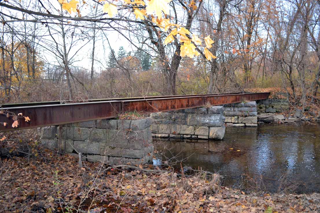
I have discovered on Google Maps three locations (to the east of Chambersburg, PA) of this old rail line. Two of them I have found in person. The third is buried on private property. Winter is the best time to locate these bridges as they are not full bridges, but fragments of steel I-beams, girders, or stone.

BRIDGE A
The first bridge is more like decking with abutments and piers can be seen to the north of Brindle Road.
I-beams left of a Chambersburg and Gettysburg Railroad bridge

View from Brindle Road of I-beams of a Chambersburg and Gettysburg Railroad bridge


I-beams left of a Chambersburg and Gettysburg Railroad bridge


I-beams left of a Chambersburg and Gettysburg Railroad bridge

BRIDGE B
Bridge remnants near Edgewood Court. Note: this road is a dead-end even though it looks complete. To locate the bridge come at it from the west.

Off Edgewood Court is a girder crossing that was once for the Chambersburg and Gettysburg Railroad


Girder bridge left of the Chambersburg and Gettysburg Railroad


BRIDGE C
The third bridge is off of Woodstock Road. It is within a thick forest of private land. I have not located it in person, but I believe it to be where the waterway makes a quick hook east and then south again.

Railroads and White Hill (now Camp Hill)

White Hill, PA? Where is that??? 
My interest in local history and railroads brought me to this question as I learned of a Cumberland Valley Railroad station located west of the Susquehanna River.

Westenhaffer's "History of the Cumberland Valley Railroad" started this adventure. He stated the Cumberland Valley Railroad opened for travel from White Hill to Carlisle in August, 1837. By November of the same year it connected to Chambersburg. I gathered White Hill was west of Harrisburg before crossing the river. Bridgeport was Lemoyne's former name so that wasn't it. New Cumberland was too far to the south.

To my surprise, Camp Hill was the town formerly known as White Hill. Here's the facts on the town's naming from Wikipedia:
The name Camp Hill is believed to stem from a split in the congregation of a Peace Church, located west of the current borough. One faction of the church began meeting outdoors, on a hill. Prior to the American Civil War, the area was known locally as White Hill, which served as a stop along the Cumberland Valley Railroad between Harrisburg and Carlisle. During the Civil War, the Battle of Sporting Hill became the northernmost engagement of the Gettysburg campaign, which took place at Camp Hill in late June 1863. Camp Hill was incorporated as a borough on November 10, 1885 from East Pennsboro Township.

Back to the railroads...
If you live around Camp Hill, you discover two sets of tracks impede your travels from north to south and vice versa. Today, the one set of tracks is used by Norfolk Southern. The other set is idle. There is talk of using the tracks for Corridor One which would provide commuter rail transportation from Carlisle to Harrisburg.
Until January 16, 1839, CVRR's trains did not cross the river. This town that sat across the river from Harrisburg was the "end of the line." Now called Camp Hill, then called White Hill, was the place where CVRR eventually located it's northern most rail yard and a brick roundhouse. Forty-eight years after this railroad began, the CVRR engine house was completed in White Hill. This would be one year before Camp Hill was incorporated.

Rewind to a time when trains were the cat's meow for travel. The CVRR dominated the south central Pennsylvania area. In the mid-1800s, Pennsylvania Railroad (PRR) had its western mainline in service, but its trains were routed north to Lewistown then to Altoona and eventually to Pittsburgh.

Location of former White Hill CVRR Station
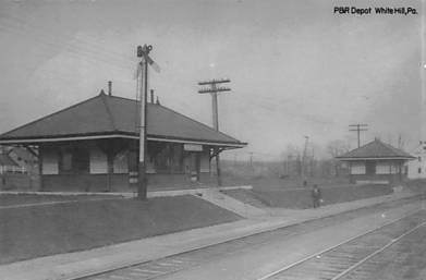
The original passenger station stood to the east of the 17th Street bridge on the south side of the tracks. Here you can see the newer 1906 CVRR White Hill station. Today, it no longer exists. In the photo to the right, you can see the 17th Street overpass in the background.  Based on the location of the power lines, I would think the 1906 station was located near the power line that is the most prominent in the photo.

For years the CVRR successfully blocked all competitors' requests to connect into their main line which connected to Harrisburg by 1839. However, The Philadelphia & Reading Railroad (P&R or the Reading) worked its way into the location later.  In 1891 the Reading built a bridge across the Susquehanna and then linked Harrisburg to Bowmansdale.  The P&R had dreams of connecting westward to Pittsburgh to battle with the B&O and CVRR. P&R built the Philadelphia, Harrisburg and Pittsburgh branch (PH&P) to Shippensburg, PA where it connected to the Western Maryland line.

An interchange point connects CVRR to the P&R line near the 1900 block of Hummel Avenue.
You can see the older triple "S" intersection here. Today it is a wye connection that allows traffic to connect to the northern track.

Looking west: P&R on left; CVRR on right. You can see the ADM Milling building (ADM Alliance Nutrition) in the one o'clock position of photo.
Looking west.
Looking East at Wye (Camp Hill station is on left past the signals in the distance).
Today, you can see P&R's station off of 18th Street.
Camp Hill P&R Station


This is the story behind the parallel tracks in Camp Hill, PA. 


SOURCES:
"History of the Cumberland Valley Railroad" Paul J. Westenhaeffer, copyright 1979
History of Dauphin, Cumberland, Perry, Bedford, Adams and Franklin Counties, PA" I.D. Rupp, copyright 1846.

Monday, December 5, 2011

Photographs from a Sunday Afternoon - Location 2

LOCATION 2: Miller Bridge (also known as Slate Hill Road Bridge) and Grist Mill

And now a word from our PENNDOT Historical Inventory:

The single lane bridge carries a 2 lane road over a stream in a rural setting.  At the southwest quadrant is the non-operative D. Miller grist mill (ca. 1870), now owned by the United Water Co., which operates a modern water treatment facility adjacent to the mill.  The mill dam and race systems have been expanded and rebuilt to service the water company.  To the northwest is a recently constructed residential subdivision.  The setting does not have the cohesiveness or integrity of a historic district.
 The 4-span, 123'-long stone arch bridge has red sandstone voussoirs at the 2 center spans, and brick arch rings at the 2 shorter end spans.  The spandrels and parapets are contrasting white limestone fieldstone.  At the north end, a section of parapet has been replaced with concrete.  Several generations of repointing have partially obscured the stone in some sections of parapet, spandrels, and intrados.  Available state and county records do not document the date of construction and the plaque has been lost, but a date of ca. 1900 is estimated based on style and comparison with 12 extant stone arch highway bridges in York County.  All of the documented examples in the county have early 20th century dates of construction.  Stone arch bridges are a traditional technology that was brought to Pennsylvania in the colonial period and used with great frequency through the early 20th century.  Over 350 examples have been identified statewide.  This example is historically and technologically distinguished in the local and regional population.  It is the longest and only example of greater than 2 spans in York County.  Although of unequal span lengths, the bridge has relatively handsome proportions and stonework exhibiting craftsmanship.
Grist Mill
Grist Mill
Grist Mill

Miller Bridge, Grist Mill, Raceway Dam
From left to right: Miller Bridge, Grist Mill, Raceway, Dam

Miller Bridge
Looking North East
The dam is behind me and the grist mill is to the right (not seen in shot).

Miller Bridge


Miller Bridge

Miller Bridge


Miller Bridge


Photographs from a Sunday Afternoon - Location 3

LOCATION 3: On Lisburn Road near Shelter lane--just a hop, skip and jump from the Camp Hill Correctional Facility.
Lisburn Road

Hay bales

Photographs from a Sunday Afternoon - Location 1

I completed my chores for the weekend but only had a few hours of daylight to spend so I couldn't venture out very far from home. I decided to visit four places within 10-15 minutes of my home. Here is one of four spots I visited.


LOCATION 1: Green Lane Bridge (also known as Etters Bridge).
Etters Bridge


This bridge crosses the Yellow Breeches and allows entry to Green Lane Farm which you can tell was a farm converted to a housing development. This bridge is VERY busy for a one lane bridge.

Overview - Through truss bridge over Yellow Breeches Creek on Green Lane Drive in Lower Allen Township
Location - Cumberland and York Counties, Pennsylvania
Status - Open to traffic
History - Built 1889
Builder - Dean & Westbrook
Design - Pratt through truss
Dimensions - 
Span length: 132.9 ft.
Total length: 132.9 ft.
Deck width: 16.2 ft.

Etters Bridge

Etters Bridge

Etters Bridge plaque

Monday, November 21, 2011

Tapeworm Railroad

When the Erie Canal  in New York opened in 1825 a panic stirred in Pennsylvania. This infrastructure posed a major threat to Philadelphia and other Pennsylvania cities in the central and eastern areas. State legislature was pushed to create the Canal Commission which broke ground a year later. The state of Pennsylvania used a railroad to connect Philadelphia with Harrisburg and then a canal along the Susquehanna from Harrisburg to Columbia, PA.


Meanwhile in 1826 a famous man by the name of Thaddeus Stevens, who was then practicing law in Gettysburg, got involved in the iron industry where he and some business partners formed Maria Furnace in Adams County.  


Stevens planned for the railroad to transport from "Columbia to York and Gettysburg and then through his ironworks at Maria Furnace to connect with the proposed Baltimore and Ohio line near Hagerstown. His approach to promoting such a line was that it would divert traffic from the B&O and funnel it toward Philadelphia, thus providing Philadelphia with a railroad to the west at no cost." [Watts, 1991]


There was much debate among politicians about granting rights for the B&O to build in Pennsylvania. Around this time there was much competition from other transportation rivalries. Private capitalists obtained from the legislature a charter for the York and Wrightsville Railroad, while Stevens obtained one from the same legislature for Wrightsville and Gettysburg Railroad. This was odd because Steven's new railway paralleled the already planned line for a portion of the distance and therefore was criticized in newspapers as the "Extra Railroad." Luckily, the charters of the two routes joined forces and merged to form the Wrightsville, York and Gettysburg Railroad Company.


So what is this Tapeworm Railroad and why am I mentioning Thaddeus Stevens? Well, it is this particular railway line that Stevens personally planned, and as you can imagine by the nickname it was not the most direct line as it had to navigate around the Green Ridge of South Mountain. Stevens had much opposition and they nicknamed it the Tapeworm Railroad. If you are patient you can see the lengthy serpentine of a line here. Note, this map was created on 1939. However, excavation for the railway began in 1936. 


Ok back to Thaddeus...many people have noted that Stevens was a shrewd politician who felt at ease using his position for personal advantage. When he was appointed President of the Canal Commission he used this influence to extend the rail line.


After the Wrightsville rail line merger, Stevens began to focus on a segment of the railway west of Gettysburg. This segment would allow construction from Gettysburg down to Williamsport, MD and the Potomac River. The C&O Canal was in full force at this time. But just as the Tapeworm Railroad began, it ended. The B&O moved its path further to the south that Stevens had planned, and by 1837 the Cumberland Valley Railroad reached Chambersburg. CVRR as a completed railroad won as the lead in this competition. Also during this time, the infamous Panic of 1837 occurred that brought much infrastructure development to a halt.


The nail in the coffin was during the 1838 elections as the Tapeworm Railroad was a main debate, but even more, Stevens lost his position on the Commission. Growing criticism of the railroad was based on expense and value. The State had spent over $766,000 on the project yet the majority felt it was better to cut the losses. The map I linked to earlier was part of a survey ordered in 1939. Thaddeus Stevens' pet railroad was put up for sale in 1842.


Some interesting features of the Tapeworm Railroad:

  • Serpentine section around Green Ridge of South Mountain
  • Switchbacks
    • on the west slope at Hughs Forge along the East Branch Antiemtam Creek (known as Cold Spring Creek in 1839) 
    • on east slope at the 1822 Maria Furnace along Toms Creek
  • Three east slope tunnels through spurs of Jacks Mountain
  • Single arch roadway bridge over Toms Creek (see photos below)
  • McPherson Ridge railway cut used in 1863 for Battle of Gettysburg, First Day
  • Seminary Ridge railway cut 

Relics of the Past
You can still find relics of the past. I will show some of what I have found.

The stone viaduct can be found in Adams County on Iron Springs Road.
stone viaduct can be found in Adams County on Iron Springs Road

stone viaduct can be found in Adams County on Iron Springs Roadstone viaduct can be found in Adams County on Iron Springs Road


stone viaduct can be found in Adams County on Iron Springs Road
Details from PA Historical Bridge Data: "The one span, 25'-long, stone arch bridge has voussoirs and spandrel walls with heavy vegetation growing in the earth fill. The bridge was built between 1836 and 1842 as part of the Tapeworm RR, a state sponsored project that was intended to connect Gettysburg with Thaddeus Stevens' iron furnaces in Franklin County. Cuts, embankments, and this stone bridge were completed before the state stopped appropriations and the project was abandoned in 1842. The line was derisively called the Tapeworm RR by its political opponents who saw the meandering line as one of the worst abuses of state-owned internal improvements. As a result of the Tapeworm RR and other canal and railroad projects, the state went heavily into debt. After 1842, state participation in internal improvements declined. The bridge is historically significant for its association with the Tapeworm RR."

Nearby is a tunnel. It now carries the CSXT RR and formerly the Western Maryland, and before that the Baltimore and Harrisburg Railway Western Extension which incorporated in 1888 and "provided a connection between the original Western Maryland mainline at Highfield and its alternate route, through Gettysburg and Hanover, to Baltimore." [Watts, 1991] You can see on the Tapeworm plan how the railway was to come up from Highfield (close to PA/MD border) to Gettysburg.

Baltimore and Harrisburg Railway Western Extension bridge tunnel
Eastern portal

Baltimore and Harrisburg Railway Western Extension bridge tunnel
Western portal


Baltimore and Harrisburg Railway Western Extension bridge tunnel
Heading north east towards Western portal
Baltimore and Harrisburg Railway Western Extension bridge tunnel
Driving through tunnel heading south west
Baltimore and Harrisburg Railway Western Extension bridge tunnel
Notice the wires go under the tunnel

Baltimore and Harrisburg Railway Western Extension bridge tunnel
Western portal


SOURCES:
"Railroads of Eastern Franklin County" Randy Watts. Copyright 1991
Pennsylvania Historical Bridge Data, PENNDOT