White Hill, PA? Where is that???
My interest in local history and railroads brought me to this question as I learned of a Cumberland Valley Railroad station located west of the Susquehanna River.
Westenhaffer's "History of the Cumberland Valley Railroad" started this adventure. He stated the Cumberland Valley Railroad opened for travel from White Hill to Carlisle in August, 1837. By November of the same year it connected to Chambersburg. I gathered White Hill was west of Harrisburg before crossing the river. Bridgeport was Lemoyne's former name so that wasn't it. New Cumberland was too far to the south.
To my surprise, Camp Hill was the town formerly known as White Hill. Here's the facts on the town's naming from Wikipedia:
The name Camp Hill is believed to stem from a split in the congregation of a Peace Church, located west of the current borough. One faction of the church began meeting outdoors, on a hill. Prior to the American Civil War, the area was known locally as White Hill, which served as a stop along the Cumberland Valley Railroad between Harrisburg and Carlisle. During the Civil War, the Battle of Sporting Hill became the northernmost engagement of the Gettysburg campaign, which took place at Camp Hill in late June 1863. Camp Hill was incorporated as a borough on November 10, 1885 from East Pennsboro Township.
Back to the railroads...
If you live around Camp Hill, you discover two sets of tracks impede your travels from north to south and vice versa. Today, the one set of tracks is used by Norfolk Southern. The other set is idle. There is talk of using the tracks for Corridor One which would provide commuter rail transportation from Carlisle to Harrisburg.
Until January 16, 1839, CVRR's trains did not cross the river. This town that sat across the river from Harrisburg was the "end of the line." Now called Camp Hill, then called White Hill, was the place where CVRR eventually located it's northern most rail yard and a brick roundhouse. Forty-eight years after this railroad began, the CVRR engine house was completed in White Hill. This would be one year before Camp Hill was incorporated.
Rewind to a time when trains were the cat's meow for travel. The CVRR dominated the south central Pennsylvania area. In the mid-1800s, Pennsylvania Railroad (PRR) had its
western mainline in service, but its trains were routed north to Lewistown then to Altoona and eventually to Pittsburgh.
 |
| Location of former White Hill CVRR Station |
The original passenger station stood to the east of the 17th Street bridge on the south side of the tracks.
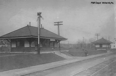
Here you can see the newer 1906 CVRR White Hill station. Today, it no longer exists. In the photo to the right, you can see the 17th Street overpass in the background. Based on the location of the power lines, I would think the 1906 station was located near the power line that is the most prominent in the photo.
For years the CVRR successfully blocked all competitors' requests to connect into their main line which connected to Harrisburg by 1839. However, The Philadelphia & Reading Railroad (P&R or the Reading) worked its way into the location lat
er. In 1891 the Reading built a bridge across the Susquehanna and then linked Harrisburg to Bowmansdale. The P&R had dreams of connecting westward to Pittsburgh to battle with the B&O and CVRR. P&R built the Philadelphia, Harrisburg and Pittsburgh branch (PH&P) to Shippensburg, PA where it connected to the Western Maryland line.
An interchange point connects CVRR to the P&R line near the 1900 block of Hummel Avenue.
You can see the older triple "S" intersection
here. Today it is a wye connection that allows traffic to connect to the northern track.
 |
| Looking west: P&R on left; CVRR on right. You can see the ADM Milling building (ADM Alliance Nutrition) in the one o'clock position of photo. |
 |
| Looking west. |
 |
| Looking East at Wye (Camp Hill station is on left past the signals in the distance). |
 |
| Camp Hill P&R Station |
This is the story behind the parallel tracks in Camp Hill, PA.
SOURCES:
"History of the Cumberland Valley Railroad" Paul J. Westenhaeffer, copyright 1979
History of Dauphin, Cumberland, Perry, Bedford, Adams and Franklin Counties, PA" I.D. Rupp, copyright 1846.


 If you go to this page http://d_cathell.tripod.com/lemo.html and scroll down to the third photo the caption explains that until a curved steel bridge was built in 1901, the Northern Central trains would have to bring their trains around the tracks in the foreground and then travel in reverse across the CVRR bridge. They did this for 50 years!


