Monday, August 29, 2016

Where to Paddle When Water Levels Are Low

Where to Go When It’s Low


The dog days of summer leads us kayakers--who love to paddle in moving water--into a quandary. 

Where is it deep enough to paddle without walking the boat?

Our hobby sometimes comes to a halt mid-summer as we suffer from what seems like near drought conditions. Like farmers, we are encouraged by thunderstorms, but their brevity doesn’t increase the flow enough to paddle with confidence. Yet we still have hope!

This list is what I call my “last ditch efforts” to paddle within 90-minutes from Harrisburg area. 

I have provided the waterway, the sections and the recommended minimum gauge height (so you don’t have to walk your boat). Cringe! 

Be careful as many waterways have dams, rock outcrops, ledges and shallows that may still require you to carefully navigate, or dare I say, walk. 

And, for all you sadomasochists who enjoy a march, feel free to ignore my blog and all gauge height recommendations and go paddle, err hike.
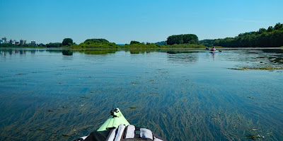
Kayak in low water where underwater grasses are seen.
On the Susquehanna River near the West Fairview access point (on the right); Harrisburg, PA is on the left.

“Last Ditch Efforts”

Susquehanna River
From Port Trevorton, PA to Harrisburg, PA
Gauge: 3.25’ Harrisburg, PA

Conestoga River 
From Mill Creek below Lancaster, PA to mouth (Susquehanna River)
Gauge: 1.4’ Conestoga, PA

Monocacy River
From Devilbiss to mouth
Gauge: 1.7’ Jug Bridge in Frederick, MD
CFS: 215

“Hopefuls” but don’t hold your breath…

Juniata River
From Raystown Branch to Mount Union, PA
Gauge: 4.0’ Huntingdon, PA
Gauge: 2.6’ Mapleton, PA

From Mount Union, PA to the mouth (Susquehanna River)
Gauge: 3.5’ Newport, PA

Schuylkill River
From Auburn, PA to Port Clinton, PA
Gauge: 5.5’ Berne, PA

From Port Clinton, PA to Muhlenburg, PA
Gauge: 5.1’ Berne, PA

Conestoga River 
Brownstown, PA to Mill Creek (south of Lancaster, PA)
Gauge: 1.9’ Conestoga, PA

Monocacy River
From Rt. 77 to Devilbiss
Gauge: 2.1’ Jug Bridge in Frederick, MD
CFS: 350

Antietam Creek
From Keedysville, MD to mouth (Potomac River)
Gauge:  2.6’ Sharpsburg, MD

CFS: 165

The next blog will cover some "gems"--waterways that are a rarity to paddle (without walking), but very enjoyable.

Monday, August 22, 2016

Mastering Logistics for a Recreational Kayak Trip

Who is this for

  • Recreational paddlers doing moving water with a put-in (start) upstream and a take-out (end) downstream.
  • Recreational paddlers wanting to know the total time of a trip. 
  • Captain organizing a recreation paddle trip with a group.

Considerations

Number of boats, gear, people and vehicles
  1. Do you have a life vest, a paddle and, as of 2012, a sound-producing device* for each person?
  2. Do you have enough boats for people?
  3. Do you have enough vehicles to transport the boats, gear and people?

Drive time: Duration from your house to the put-in or take-out or back home

Shuttle time: Duration of shuttle
  • This is personal preference, but the shorter the shuttle, the more time for fun. 10-20 minutes is typical.
  • See my blog on Shuttling Step-by-Step

Distance to paddle (miles)
  • The number of miles helps determine if it is a casual afternoon paddle, a day paddle or an overnight camping trip paddle.

Float time
  • I call this float time, but if you are in a waterway with a current and obstacles, you might find yourself paddling just to keep in control. So factor in that it is a mix of paddling, floating and even a break for a stretch. These averages are on the low side because I factor in breaks. I’m old—I need to stretch. I’m young—I need to explore.
  • In the summer when water is flowing low and slow, divide the distance (miles) by 2mph. For example, a 7-mile trip will take 3.5 hours to float.
  • When water is moving (note spikes in CFS**) or you will be doing a constant paddle, divide the distance (miles) by 3mph. So a 12-mile trip will take 4 hours.

Food and drinks
  • Check out this nerdery: A Hyrdation Calculator by CamelBak…I love it 
  • My general rule is to have 16 oz. per hour. So a 4-hour trip would mean I bring (2) 32-oz. water containers. Also, I like cold water so I put in lots of ice and keep it in a cooler with ice packs.

Time Constraints (e.g., sunset, dinner plans, babysitter needs to leave)
  • This is the tricky part. Calculate it using the formula below and back time it. For example, if your total time <<feel free to use 2mph to be sure you have enough time versus the average of 2.5mph>>

Calculation Example

A 10-mile trip with a 15-minute drive and shuttle each way would take approximately 6 hours and 30 minutes. This means if your group had to be back by 5pm, then don’t leave the house later than 10:30 AM.

Juniata River – Howe Park (3 miles south of Newport, PA) to Ann Street in Duncannon is 10-miles. The float time is 4 hours. The shuttle is 15 minutes one-way. However, from my house, the drive to put-in is 40-minutes and the drive from take-out is 35 minutes. So I average up and down to nearest quarter of an hour, and use 45-minutes as the total unpacking/packing.

Example with 2 people, 2 boats, 2 vehicles
Drive to take-out = .5 hr
Shuttle 1-way = .25 hr.
Unpack = .25 hr.
Float = 4 hours
Pack = .5 hr.
Shuttle 1 way = .25 hr.
Drive home = .75 hr.
TOTAL = 6.5 hours


Example with 4 people, 4 boats, 2 vehicles
Drive to put-in = .75 hr
Shuttle 2-way = .5 hr.
Unpack = .25 hr.
Float = 4 hours
Pack = .5 hr.
Shuttle 2-way = .5 hr.
Drive home = .5 hr.
TOTAL = 7 hours


Did you know?

*The Pennsylvania Boating Handbook lists in Chapter 2 the “operators of unpowered boats (canoes, kayaks, rowboats, paddleboards) are required to carry a device capable of sounding a prolonged blast for 4-6 seconds that can be heard by another boat operator in time to avoid a collision. An athletic coach’s whistle is acceptable.”

**CFS means Cubic Feet per Second

Monday, August 8, 2016

Shuttling Kayaks Step-By-Step

Shuttling

Shuttling kayaks is necessary when it is desired to paddle in moving water. Shuttling is the act of moving cars from the take-out to the put-in or vice versa. These are guidelines based on most vehicles hauling 2 boats--usually on a roof rack. 
A COMMENT ON ROOF RACK WEIGHT
Whether you use OEM rails and racks, or an aftermarket brand like Yakima or Thule, you must know the weight limit on these components--and go with the lowest number. For example, your Yakima rack may hold 200# but if your SUV’s rails, that this rack sits on, only holds 100# then you are limited to 100#. So if you are planning to carry two Pungo 140s at 58# each, then you might want to reconsider your plan.
With some ingenuity, I am sure you can find ways to make your shuttle easier. Perhaps, befriend someone who owns a pickup with an 8’ truck or someone with a beater van, and you can stack 4 boats easily in one vehicle. I’ve also seen many homemade trailers that haul multiple boats behind the vehicle.

Remember to bring your keys in a waterproof container and latch it to your boat when paddling.

The easiest trip is 2 people, 2 boats, 2 vehicles. 

2 people, 2 boats, 2 vehicles

  1. Load both boats on one vehicle. 
  2. Meet at take-out. 
  3. Drop the unloaded vehicle at the take out.
  4. Drive the loaded vehicle to the put-in.

Variation 
  1. Two people, each with boats on their vehicle can meet at take-out
  2. Load a boat from one vehicle to another so now a vehicle has 2 boats. 
  3. Leave the unloaded boat at the take-out
  4. Drive the loaded vehicle to the put-in.

3-4 people, 3-4 boats, 2 vehicles

  1. Load 2 boats on each vehicle.
  2. Meet at put-in.
  3. Unload boats and gear.
  4. Leave 1-2 people to watch boats and gear. 
  5. Drive the 2 cars to take-out. 
  6. Leave 1 car and return to put-in in the other.

Example

Juniata River – Howe Park (3 miles south of Newport, PA) to Ann Street in Duncannon.

For 2 people, 2 boats, 2 vehicles

  1. We would meet at take-out (Ann St.). 
  2. Drop one car off 
  3. Ride together in the other with both boats to put-in (Howe Township Park).
  4. Float downstream.
  5. We would load both cars on the car at the take-out.
  6. Then we'd drive up to retrieve the car at the put-in and drive home.

For 4 people, 4 boats, 2 vehicles

  1. We would meet at put-in (Howe Township Park) and unload all boats and gear. 
  2. Drop off a car at the take-out (Ann St.) 
  3. We'd return with the other car to the put-in . 
  4. Float downstream.
  5. We would retrieve the car at the put-in.
  6. Then we would load both cars at the take-out and drive home. 
I hope that helps! Feel free to add your questions, tips or 2 cents in the comments. Thanks for reading.

Wednesday, August 3, 2016

Commute via Swatara Creek

"Commuters Guide Volume 3"

<<SARCASM DISCLOSURE...However, all the paddling information is true.>>

Summers in Pennsylvania signal heavy traffic, accidents on our major highways, as well as lane closures and detours while PennDOT repairs the roads. A beautiful and refreshing alternative to I-81, PA-39 and US-22 is the Swatara Creek. You can hop on as north as Pine Grove, Pennsylvania and float past Jonestown, Hershey, Hummelstown, Middletown and even further south to Goldsboro via the Susquehanna River. Summer also indicates vacation time, and this creek offers many sights to see while you use this waterway as the throughway to your vacation spot—whether a campground, amusement park or to fly to another destination.

Thinking about the name of this creek might make you hungry. Swatara is derived from a Susquehannock word which means “where we feed on eels.” So pick up your kayak, life vest, paddle and eel trap today! Well, unfortunately today this creek doesn’t have has many eels so bring snacks instead of the trap.


In fact, in August 1, 2016 DEP declared Swatara Creek (along with the Susquehanna River and the Conodoguinet Creek) impaired for recreation and aquatic life. But don’t let that stop you from enjoying the waterways. It’s mostly a warning for fish (or eel) consumption. Let’s hope DEP, the businesses and community surrounding these waterways support taking measures to return these waterways to being healthy so we and generations after us can enjoy them and their bounty.
 

The Swattie originates in the Appalachian Mountains in central Schuylkill County, approximately five miles west of Minersville. A railroad branch of the now Reading Blue Mountain and Northern Railroad follows the creek into Tremont. This creek was clearly convenient for transporting anthracite to cities in the 19th century.


In addition to seeing farms, forested riparian buffers and some civilization, especially around towns like Hummelstown, sights to soak in on this creek include the Swatara State Park, the abandoned Lebanon to Tremont railroad bridge, Harper's Tavern, limestone outcrops, the only lava deposits in the state, Middle to Hummelstown railroad bridge, TMI in the distance and Union Canal locks. I have a little more on the canal at the end of the blog.

The Route

There are two dams that are hindrances with terrible portages so I broke the creek into three sections.


Sections, Gauges & Water Levels

  • Section A (Pine Grove to Rt. 22) To start at Pine Grove, Harper Tavern should be over 2.5’; To get through Swatara State Park, Inwood should be 3.25’.

  • Section B (Jonestown to Boat House Road Park in Hershey) For the stretch between Jonestown to Water Works, Inwood should be 2.85’ and Harper Tavern should be 0.85’; For Water Works to Boat House Road Park, Harper Tavern should be at 2.1’.
  • Section C (South Hanover Park in Hershey to Goldsboro) For the stretch from Hershey to Middletown, Hershey should be 2.0 (For Fulling Mill to Middletown, you can get away with Hershey at 1.90’ as long as the Susquehanna is over 4’). 

Commute Times (and vacation ideas)

These times are based on proper water conditions, great weather, no headwind and you are paddling the whole time.
  • Coming from Pine Grove to stay at the campground in Lickdale will take you almost 4.5 hours.
  • If you live in Jonestown and work/visit The Hotel Hershey, you will paddle a beautiful section of 22.5 miles in seven hours.
  • Maybe you live in Ono (put-in at Water Works) and work at Fort Indiantown Gap (take -out at Harper Tavern). The paddle would only take you to 1.5 hours.
  • If you live in Hummelstown and work at TE Connectivity in Middletown, you are looking at a commute of less than two hours—not bad unless you have to wear a suit because you are bound to get splashed at Fiddler’s Elbow.
  • Jonestown dwellers can visit Hollywood Casino in about 4.5 hours and then continue to Hershey Park in less than two hours.

Wildlife You Might See

  • Bald Eagle
  • Great Blue Herons
  • Green Herons
  • Mallard Ducks
  • Wood Ducks
  • Snapping Turtles
  • Box Turtles

About the Swatara and the Union Canal

The historical significance of the Swattie is quite interesting. In 1690, William Penn proposed to build a canal to connect the Susquehanna and Delaware valleys in southeastern Pennsylvania. The notion stood idle for nearly a century until the discovery of anthracite in the northern Susquehanna valley motivated Philadelphia businessmen to push for feeding commercial traffic away from Baltimore, a rival shipping port and to their city. The Pennsylvania General Assembly chartered two companies, and construction began in 1792 with President George Washington breaking ground and shoveling the initial load. By 1828, 36 years later, the canal was open for business.

The Union Canal turned its focus to connecting the Susquehanna to the Schuylkill because another canal had already taken over the Schuylkill passage into Philadelphia. Middletown was the western terminus, allowing products to avoid follow the Susquehanna down to the Chesapeake Bay, and Reading was the eastern terminus at the Schuylkill River. Four years later in 1832, in an area called Union Water Works, south of Ono, a 22-mile branch was built along the Swattie heading north to Pine Grove and serving as a feeder for the summit level. The businessmen of Philadelphia reaped financial benefits of this canal with the transport of anthracite from the mountains down to Philadelphia. We benefit by seeing remnants of this canal all along the creek.

Resources

Map & Info

Gauge Data