Where to Go When It’s Low
The dog days of summer leads us kayakers--who love to paddle
in moving water--into a quandary.
Where is it deep enough to paddle without
walking the boat?
Our hobby sometimes comes to a halt mid-summer as we suffer
from what seems like near drought conditions. Like farmers, we are encouraged
by thunderstorms, but their brevity doesn’t increase the flow enough to paddle
with confidence. Yet we still have hope!
This list is what I call my “last ditch efforts” to paddle
within 90-minutes from Harrisburg area.
I have provided the waterway, the
sections and the recommended minimum gauge height (so you don’t have to walk
your boat). Cringe!
Be careful as many waterways have dams, rock outcrops, ledges and
shallows that may still require you to carefully navigate, or dare I say, walk.
And, for all you sadomasochists who enjoy a march, feel free to ignore my blog and all gauge height recommendations and go paddle, err hike.
 |
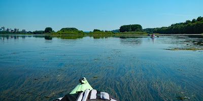
| On the Susquehanna River near the West Fairview access point (on the right); Harrisburg, PA is on the left. |
“Last Ditch Efforts”
Susquehanna River
From Port Trevorton, PA to Harrisburg, PA
Gauge: 3.25’ Harrisburg, PA
Conestoga River
From Mill Creek below Lancaster, PA to mouth (Susquehanna River)
Gauge: 1.4’ Conestoga, PA
Monocacy River
From Devilbiss to mouth
Gauge: 1.7’ Jug Bridge in Frederick, MD
CFS: 215
“Hopefuls” but don’t hold your breath…
Juniata River
From Raystown Branch to Mount Union, PA
Gauge: 4.0’ Huntingdon, PA
Gauge: 2.6’ Mapleton, PA
From Mount Union, PA to the mouth (Susquehanna River)
Gauge: 3.5’ Newport, PA
Schuylkill River
From Auburn, PA to Port Clinton, PA
Gauge: 5.5’ Berne, PA
From Port Clinton, PA to Muhlenburg, PA
Gauge: 5.1’ Berne, PA
Conestoga River
Brownstown, PA to Mill Creek (south of Lancaster, PA)
Gauge: 1.9’ Conestoga, PA
Monocacy River
From Rt. 77 to Devilbiss
Gauge: 2.1’ Jug Bridge in Frederick, MD
CFS: 350
Antietam Creek
From Keedysville, MD to mouth (Potomac River)
Gauge: 2.6’ Sharpsburg,
MD
CFS: 165
The next blog will cover some "gems"--waterways that are a rarity to paddle (without walking), but very enjoyable.
No comments:
Post a Comment